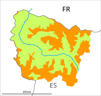
Danger level
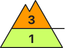
2000m
Avalanche Problem

Wind-drifted snow

2000m

Wind slabs represent the main danger.
The northwesterly wind will transport the fresh and old snow significantly. The fresh wind slabs will form in particular on northeast, east and south facing slopes and generally at high altitudes. This applies in particular adjacent to ridgelines and in gullies and bowls. Wind slabs can to an increasing extent be released very easily or triggered naturally. Mostly the avalanches are small.
The older wind slabs of the last few days will be covered with new snow in some cases and therefore difficult to recognise. These can in isolated cases be triggered in the old snowpack and reach medium size in particular on steep, little used shady slopes.
On wind-protected shady slopes dry loose snow slides are possible, but they will be mostly small.
Snowpack
>Up to 5 cm of snow will fall in the next few hours in all altitude zones. Shady slopes and in places that are protected from the wind: The upper section of the snowpack is soft; its surface consists of faceted crystals.
Wind-loaded slopes: Various wind slab layers are lying on soft layers.
Towards its base, the snowpack is favourably layered.
Sunny slopes: The surface of the snowpack will freeze to form a strong crust and will hardly soften at all.
The current avalanche situation calls for defensive route selection.
Tendency
As a consequence of rising temperatures, solar radiation and the moderate to strong northwesterly wind, a precarious avalanche situation will develop on Saturday.