Danger level
2000m
Avalanche Problem
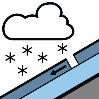
New snow

2000m


Wind-drifted snow
2300m
The Avalanche Warning Service currently has only a small amount of information about the snowpack, so that the avalanche danger should be investigated especially thoroughly in the relevant locality.
New snow and wind slabs are to be assessed with care and prudence.
The cold fresh snow and the mostly small wind slabs that are forming during the snowfall must be evaluated with care and prudence in all aspects above approximately 2000 m. Dry avalanches can in many places be released easily or triggered naturally. The avalanche prone locations are to be found in particular on steep shady slopes above approximately 2000 m and on near-ridge sunny slopes above approximately 2300 m. As a consequence of solar radiation the prevalence and size of the avalanche prone locations will increase as the day progresses. At elevated altitudes these avalanche prone locations are more prevalent and larger.
Backcountry touring calls for meticulous route selection. Restraint is advisable on this first sunny day.
Backcountry touring calls for meticulous route selection. Restraint is advisable on this first sunny day.
Snowpack
>Over a wide area 10 to 20 cm of snow, and even more in some localities, will fall until Monday above approximately 1500 m. In particular high altitudes and the high Alpine regions and adjacent to ridgelines: The northwesterly wind will transport the new snow. The new snow and wind slabs will become increasingly prone to triggering in all aspects. Over a wide area new snow and wind slabs are lying on a moist old snowpack.
In all regions at intermediate and high altitudes less snow than usual is lying. At low altitude from a snow sport perspective, insufficient snow is lying.
In all regions at intermediate and high altitudes less snow than usual is lying. At low altitude from a snow sport perspective, insufficient snow is lying.
Tendency
Gradual increase in danger of moist avalanches as a consequence of warming during the day and solar radiation.