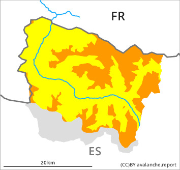
Danger level

2200m
Avalanche Problem

Wind slab

2200m


New snow
1600m

New snow and wind slabs require caution. In the course of the day the wind slabs will increase in size additionally.
The fresh and somewhat older wind slabs can be released easily. or in isolated cases naturally, in particular on shady slopes and at high altitudes and in high Alpine regions. Sometimes the avalanches are medium-sized. The avalanche prone locations are to be found especially adjacent to ridgelines above approximately 2200 m and in gullies and bowls, and behind abrupt changes in the terrain. These places are covered with new snow and are therefore difficult to recognise.
As a consequence of the snowfall, the likelihood of dry avalanches being released will increase a little in all aspects above approximately 1600 m. In isolated cases the avalanches in these regions are medium-sized and in many cases easily released.
Backcountry touring and other off-piste activities call for careful route selection.
Snowpack
>
20 to 30 cm of snow, and even more in some localities, has fallen since Saturday. Over a wide area 15 to 20 cm of snow will fall until Monday above approximately 1600 m. The southerly wind will transport the new snow and, in some cases, old snow as well.
The new snow and wind slabs have bonded well with the old snowpack in all aspects. Above approximately 1800 m there are 60 to 100 cm of snow, and even more in some localities. At high altitudes and in high Alpine regions snow depths vary greatly, depending on the infuence of the wind.
The new snow and wind slabs have bonded well with the old snowpack in all aspects. Above approximately 1800 m there are 60 to 100 cm of snow, and even more in some localities. At high altitudes and in high Alpine regions snow depths vary greatly, depending on the infuence of the wind.
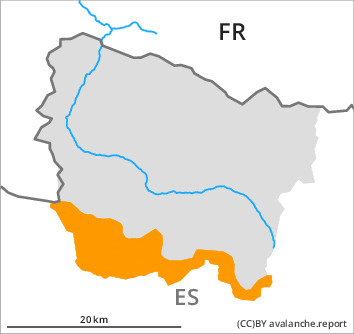
Tendency
Easter Monday: Gradual decrease in avalanche danger as the precipitation eases.