Danger level

treeline
Avalanche Problem

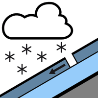
New snow

Treeline


From today Friday 6 December the avalanche bulletin will appear daily at 5 pm.
New snow and wind slabs from the middle of the day.
As a consequence of new snow and stormy weather more frequent dry avalanches are possible from midday, but they will be mostly small. Dry avalanches can be released easily or triggered naturally. The avalanche prone locations are to be found in particular on wind-protected shady slopes at elevated altitudes. Towards the evening possibly danger level 2 (moderate) will be reached at high altitude.
Snowpack
>
At high altitude a little snow is lying on north facing slopes. At low and intermediate altitudes no snow is lying.
Saturday: 20 to 30 cm of snow will fall until the evening. The wind will be strong to storm force. The snowpack will become unfavourable in particular on wind-loaded slopes.
Saturday: 20 to 30 cm of snow will fall until the evening. The wind will be strong to storm force. The snowpack will become unfavourable in particular on wind-loaded slopes.
Tendency
Sunday: Sharp increase in danger of dry avalanches as the snowfall becomes more intense.