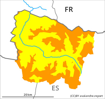
Danger level

treeline
Avalanche Problem

Wind slab

Treeline


Persistent weak layer
2200m

The wind slabs represent the main danger. Weak layers in the old snowpack necessitate defensive route selection.
As a consequence of new snow and a sometimes strong northerly wind, sometimes deep wind slabs will form during the course of the night adjacent to ridgelines in all aspects. In all aspects they will increase in size as the day progresses. Sometimes the avalanches are medium-sized and can be released easily by a single winter sport participant. At the southern and eastern borders of Aran these avalanche prone locations are more prevalent.
Dry avalanches can additionally be released in deeper layers in particular on little-used, rather lightly snow-covered shady slopes. Sometimes the avalanches in these loacations are medium-sized.
All aspects and low and intermediate altitudes: As a consequence of warming dry and moist avalanches are possible from midday, but they will be mostly small.
Ski touring and other off-piste activities, including snowshoe hiking, call for experience and great restraint.
Snowpack
>
Over a wide area 15 to 20 cm of snow, but less in some localities, will fall until the early morning above approximately 1500 m. The northerly wind will transport the new snow significantly.
Shady slopes, areas where the snow cover is rather shallow: Faceted weak layers exist in the snowpack.
At intermediate altitudes there are 60 to 100 cm of snow, and even more in some localities. At elevated altitudes snow depths vary greatly, depending on the infuence of the wind.
Shady slopes, areas where the snow cover is rather shallow: Faceted weak layers exist in the snowpack.
At intermediate altitudes there are 60 to 100 cm of snow, and even more in some localities. At elevated altitudes snow depths vary greatly, depending on the infuence of the wind.
Tendency
Friday: Gradual increase in danger of dry avalanches as a consequence of new snow and stormy weather.