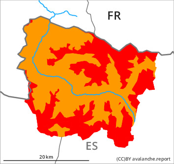
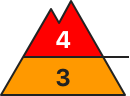
Danger level
treeline
Avalanche Problem

Wind slab

Treeline


New snow
1200m
The conditions are very dangerous for ski touring, freeriding and snowshoe hiking.
A very large quantity of fresh snow and the extensive wind slabs can be released easily or naturally.
As a consequence of new snow and a strong to storm force northwesterly wind, sometimes large wind slabs will form during the course of the night in particular above the tree line. The number and size of avalanche prone locations will increase as the day progresses. Remotely triggered and natural avalanches are possible.
Dry avalanches can release deeper layers of the snowpack and reach large size on shady slopes.
All aspects and in places that are protected from the wind: As a consequence of the heavy snowfall more frequent dry snow slides and avalanches are to be expected, even medium-sized ones.
The avalanche prone locations are widespread and are barely recognisable because of the poor visibility.
Snowpack
>
Up to 10 cm of snow has fallen since yesterday above approximately 1400 m. Over a wide area 50 to 60 cm of snow, and even more in some localities, will fall on Sunday above approximately 1200 m. The sometimes strong wind will transport the new snow significantly. The wind slabs have bonded poorly with each other and the old snowpack.
Shady slopes areas where the snow cover is rather shallow: Faceted weak layers exist in the snowpack.
At intermediate altitudes there are 70 to 100 cm of snow, and even more in some localities.
Shady slopes areas where the snow cover is rather shallow: Faceted weak layers exist in the snowpack.
At intermediate altitudes there are 70 to 100 cm of snow, and even more in some localities.
Tendency
Sunday: Gradual decrease in danger of dry avalanches as a consequence of the ceasing of precipitation. Increase in danger of moist avalanches as a consequence of warming during the day and solar radiation.