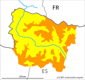
Danger level

2200m
Avalanche Problem

Wind slab

2200m

Gliding snow
2400m
The wind slabs must be evaluated with care and prudence in all aspects.
As a consequence of new snow and a sometimes moderate northwesterly wind, avalanche prone wind slabs will form during the course of the night especially adjacent to ridgelines and in pass areas as well as at high altitudes and in high Alpine regions. The fresh and somewhat older wind slabs can be released easily. or in isolated cases naturally, in all aspects above approximately 2200 m. Sometimes avalanches are medium-sized.
As a consequence of the new snow dry snow slides and avalanches are possible, but they will be mostly small.
Dry avalanches can also be triggered in the old snowpack and reach large size in isolated cases.
All aspects: Gliding avalanches can be released at any time of day or night. In isolated cases Explanation: "these" may only stand for "these avalanches" are medium-sized. Areas with glide cracks are to be avoided as far as possible.
Backcountry touring and other off-piste activities call for experience in the assessment of avalanche danger.
Snowpack
>
5 to 10 cm of snow, but less in some localities, will fall until late morning above approximately 1500 m.
Especially adjacent to ridgelines and in gullies and bowls and high altitudes: The northwesterly wind will transport the new snow significantly.
Large-grained weak layers exist in the bottom section of the old snowpack in particular on rather lightly snow-covered west, north and east facing slopes.
At intermediate altitudes there are 120 to 160 cm of snow, and even more in some localities.
Tendency
As a consequence of new snow and stormy weather the prevalence of the avalanche prone locations will increase on Saturday.