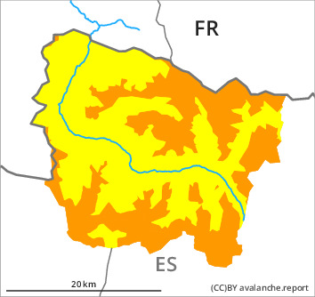
Danger level

treeline
Avalanche Problem

Wind slab

Treeline

Gliding snow


The avalanche conditions remain wintry at high altitude.
Fresh wind slabs represent the main danger. Gliding avalanches and loose snow slides require caution.
As a consequence of new snow and a sometimes strong southerly wind, further wind slabs formed in particular in gullies and bowls and behind abrupt changes in the terrain. The fresh and somewhat older wind slabs can be released easily. or in isolated cases naturally, in all aspects above the tree line. They will be covered with new snow and therefore difficult to recognise. Sometimes avalanches are medium-sized. They can in isolated cases be triggered in the old snowpack and reach dangerously large size. At the border to Ribagorça and Pallars the avalanche prone locations are more prevalent and larger.
As the temperature drops there will be a gradual decrease in the danger of moist avalanches during the course of the night. The danger of gliding avalanches will not decrease for the time being. During the day: As a consequence of solar radiation small loose snow slides are possible.
The current avalanche situation calls for experience and restraint.
Snowpack
>
In particular in the south and in the east 20 cm of snow, and even more in some localities, has fallen since Monday. The southerly wind has transported the new snow significantly. The various wind slabs of the last few days remain prone to triggering in all aspects above the tree line. Some snow will fall until the evening in particular at the southern and eastern borders of Aran. The sometimes strong wind will transport the new snow. On Friday it will be cold. The fresh and somewhat older wind slabs remain prone to triggering.
Large-grained weak layers exist in the bottom section of the old snowpack in particular on west, north and east facing slopes. Areas where the snow cover is rather shallow where hard layers are lying on a weakly bonded old snowpack are especially precarious. At intermediate altitudes there are 120 to 200 cm of snow, and even more in some localities.
Large-grained weak layers exist in the bottom section of the old snowpack in particular on west, north and east facing slopes. Areas where the snow cover is rather shallow where hard layers are lying on a weakly bonded old snowpack are especially precarious. At intermediate altitudes there are 120 to 200 cm of snow, and even more in some localities.
Tendency
Saturday: Some snow will fall until late morning. Further increase in danger of dry avalanches as a consequence of the new snow.