Danger level

treeline
Avalanche Problem

Wind slab

Treeline


Persistent weak layer
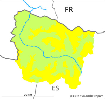
2300m

Wind slabs and weakly bonded old snow require caution.
As a consequence of new snow and a moderate to strong northwesterly wind, mostly small wind slabs will form during the night adjacent to ridgelines and in gullies and bowls as well as above the tree line. The clearly visible wind slabs can be released easily or naturally. High altitudes, steep shady slopes: The wind slabs have bonded very poorly.
Weak layers in the old snowpack can be released in some places by people especially on wind-protected shady slopes. Sometimes they are medium-sized.
The current avalanche situation calls for experience in the assessment of avalanche danger.
Weak layers in the old snowpack can be released in some places by people especially on wind-protected shady slopes. Sometimes they are medium-sized.
The current avalanche situation calls for experience in the assessment of avalanche danger.
Snowpack
>
Thursday: 2 cm of snow, and even more in some localities, has fallen since yesterday. The wind will be moderate to strong adjacent to ridgelines in particular at the southern and eastern borders of Aran. The northwesterly wind will transport the new snow and, in some cases, old snow as well. The new snow and wind slabs will be deposited on the unfavourable surface of an old snowpack in particular on steep shady slopes above approximately 2300 m. The weather will be cold.
In particular high altitudes in shady places that are protected from the wind: Large-grained weak layers exist in the top section of the snowpack. Stability tests indicate the unfavourable bonding of the snowpack in these regions.
At intermediate altitudes there are 100 to 200 cm of snow, and even more in some localities. Snow depths vary greatly at high altitudes and in high Alpine regions, depending on the infuence of the wind.
Tendency
Friday: The avalanche danger will persist.