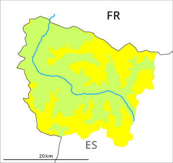
Danger level
2000m
Avalanche Problem

Wind-drifted snow

2000m


Wet snow

Wind slabs represent the main danger. Gliding avalanches and moist snow slides during the day are still possible.
As a consequence of new snow and a moderate to strong northwesterly wind, hard wind slabs formed on Sunday in particular on east and south facing slopes. These can be released by a single winter sport participant and reach medium size. These avalanche prone locations are to be found in particular on very steep east and south facing slopes at intermediate and high altitudes and adjacent to ridgelines and in gullies and bowls.
The older wind slabs can be released by a single winter sport participant in isolated cases in all aspects and at intermediate and high altitudes. These can in isolated cases be triggered in the old snowpack and reach medium size in particular on steep, little used shady slopes.
As a consequence of warming during the day and solar radiation gliding avalanches and moist snow slides are possible from midday, but they will be mostly small. This applies on very steep sunny slopes and in all altitude zones.
Snowpack
>The more recent wind slabs represent the main danger. In isolated cases wind slabs are lying on a weakly bonded old snowpack.
Low altitudes: The surface of the snowpack will freeze to form a strong crust and will soften during the day. This applies in particular on steep sunny slopes.
The current avalanche situation calls for meticulous route selection.
Low altitudes: The surface of the snowpack will freeze to form a strong crust and will soften during the day. This applies in particular on steep sunny slopes.
The current avalanche situation calls for meticulous route selection.
Tendency
As a consequence of a moderate southwesterly wind, mostly small wind slabs will form on Wednesday in particular above the tree line.