Danger level
Avalanche Problem

Wet snow


Wind-drifted snow

2600m

Wet and gliding snow represent the main danger.
As a consequence of warming during the day and solar radiation small and, in isolated cases, medium-sized natural moist avalanches are to be expected. Gliding avalanches are also to be expected.
Fresh and older wind slabs are to be found in particular at elevated altitudes. These can still in isolated cases be released by a single winter sport participant.
Fresh and older wind slabs are to be found in particular at elevated altitudes. These can still in isolated cases be released by a single winter sport participant.
Snowpack
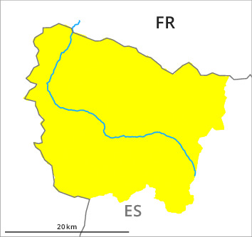
>Up to 2500 m rain fell on Wednesday over a wide area. The surface of the snowpack will only just freeze and will already soften in the late morning. The high temperatures as the day progresses will give rise to increasing moistening of the snowpack in particular on steep southeast, south and southwest facing slopes below approximately 2200 m. 2 to 5 cm of snow will fall until midday above approximately 2000 m.
In very isolated cases various wind slab layers are lying on old snow containing large grains. This applies especially above approximately 2500 m.
Backcountry touring and other off-piste activities call for defensive route selection.
In very isolated cases various wind slab layers are lying on old snow containing large grains. This applies especially above approximately 2500 m.
Backcountry touring and other off-piste activities call for defensive route selection.
Tendency
The danger of dry avalanches will increase significantly during the day.