Danger level
Avalanche Problem

Wind-drifted snow

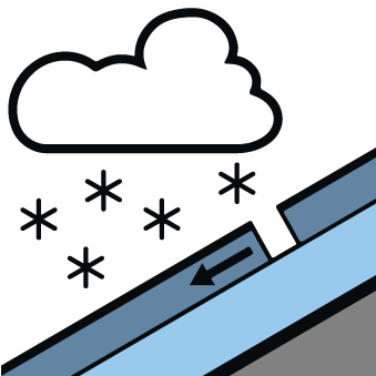
New snow

New snow and wind slabs represent the main danger.
The cold fresh snow as well as the wind slabs that are being formed by the light to moderate northwesterly wind are bonding poorly with the old snowpack. Avalanches can be released by a single winter sport participant and reach medium size. The avalanche prone locations are to be found in particular adjacent to ridgelines and in pass areas and in shady places that are protected from the wind. At elevated altitudes these avalanche prone locations are more prevalent and larger.
Individual gliding avalanches can also occur.
The current avalanche situation calls for experience in the assessment of avalanche danger. The avalanche prone locations are numerous and are barely recognisable because of the poor visibility.
Individual gliding avalanches can also occur.
The current avalanche situation calls for experience in the assessment of avalanche danger. The avalanche prone locations are numerous and are barely recognisable because of the poor visibility.
Snowpack
>The new snow of last week has bonded in all aspects and in all altitude zones.
15 to 25 cm of snow fell in the past few hours in all altitude zones. 15 to 20 cm of snow will fall until the afternoon. This snow and the wind slabs that are forming during the snowfall will be deposited on a crust in all aspects and in all altitude zones. Up to intermediate altitudes rain will fall during the night.
Especially in places that are protected from the wind a lot of snow is lying for the time of year in all altitude zones. Above the tree line snow depths vary greatly, depending on the infuence of the wind.
Tendency
Thursday: A lot of rain will fall in the evening. Significant increase in avalanche danger as the snowfall level rises. Danger level 4 (high) will be reached during the first half of the night probably.
Friday: A lot of snow will fall until the evening. The wind will be storm force over a wide area. Avalanches can reach valley bottoms and endanger exposed transportation routes.
Friday: A lot of snow will fall until the evening. The wind will be storm force over a wide area. Avalanches can reach valley bottoms and endanger exposed transportation routes.