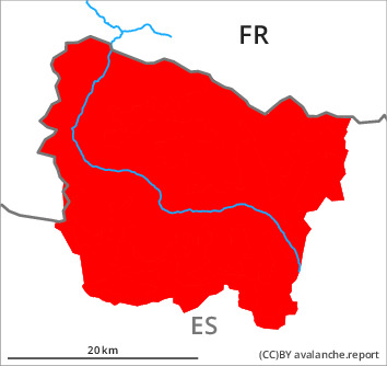
Danger level
Avalanche Problem

Wind-drifted snow


Gliding snow
The large quantity of fresh snow and in particular the widespread extensive wind slabs must be evaluated with care and prudence.
Sharp increase in danger of wet and gliding avalanches.
Sharp increase in danger of wet and gliding avalanches.
The new snow of the last four days will become increasingly prone to triggering in particular on southeast, south and west facing slopes and in all altitude zones. A great many medium-sized and large wet and gliding avalanches are to be expected as a consequence of warming during the day and solar radiation.
The wind slabs can still be released in some cases in all aspects and in all altitude zones, especially at their margins. The avalanches in these loacations are quite large but can mostly only be released by large loads.
Medium-sized and, in isolated cases, large avalanches are possible also in places that are protected from the wind. These can as before be released by people.
At elevated altitudes the avalanche prone locations are more prevalent and larger. In isolated cases avalanches can penetrate deep layers and reach very large size.
The conditions are dangerous for ski touring, freeriding and snowshoe hiking outside marked and open pistes.
Snowpack
>
Since Thursday numerous large and, in isolated cases, very large avalanches occurred naturally.
140 to 170 cm of snow, and even more in some localities, has fallen since Wednesday above approximately 2000 m.
In the next few hours the weather will be warm. On Sunday it will be sunny.
In all regions in all altitude zones a very large amount ofsnow is lying for the time of year.
140 to 170 cm of snow, and even more in some localities, has fallen since Wednesday above approximately 2000 m.
In the next few hours the weather will be warm. On Sunday it will be sunny.
In all regions in all altitude zones a very large amount ofsnow is lying for the time of year.
Tendency
Monday: Outgoing longwave radiation during the night will be quite good. In all aspects there will be a significant decrease in the danger of dry and moist avalanches to level 3 (considerable).