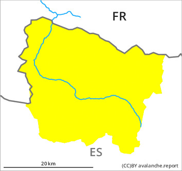
Danger level

2200m
Avalanche Problem

Wind-drifted snow

2200m

Gliding snow


Fresh wind slabs at high altitude. Gliding avalanches and moist avalanches require caution.
As a consequence of the rain more ground avalanches are possible at any time, in particular medium-sized ones. The avalanche prone locations are to be found in particular on west, north and east facing slopes at low and intermediate altitudes and on south facing slopes in all altitude zones. Areas with glide cracks are to be avoided.
As a consequence of new snow and a moderate to strong westerly wind, sometimes avalanche prone wind slabs will form in the course of the day adjacent to ridgelines on northeast, east and southeast facing slopes. They can be released by people, but they will be small in most cases. The avalanche prone locations are rare but are barely recognisable because of the poor visibility.
As a consequence of new snow and a moderate to strong westerly wind, sometimes avalanche prone wind slabs will form in the course of the day adjacent to ridgelines on northeast, east and southeast facing slopes. They can be released by people, but they will be small in most cases. The avalanche prone locations are rare but are barely recognisable because of the poor visibility.
Snowpack
>
The weather report and anticipated change in the avalanche danger are uncertain. We recommend that you consult the most recent avalanche bulletin. Up to 2500 m rain will fall on Tuesday. The rain will give rise as the day progresses to increasing softening of the snowpack in particular at low and intermediate altitudes.
A lot of snow is lying for the time of year in all altitude zones.
A lot of snow is lying for the time of year in all altitude zones.
Tendency
Wednesday: Slight decrease in danger of gliding avalanches and moist snow slides as a consequence of the ceasing of precipitation.