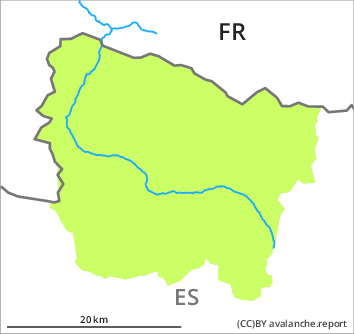
Danger level
Avalanche Problem

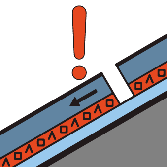
Wind-drifted snow


Persistent weak layer

2000m

Fresh and older wind slabs represent the main danger.
Fresh wind slabs will form adjacent to ridgelines on east and south facing slopes. The avalanches in these loacations are only small but can be released easily by a single winter sport participant.
The older wind slabs can still be released in some cases on west, north and east facing slopes. They are lying on weak layers on shady slopes above approximately 2000 m. In the south and in the east these avalanche prone locations are more prevalent and the danger is slightly greater.
On extremely steep shady slopes and in places that are protected from the wind dry snow slides are possible, but they will be mostly small.
The conditions are generally favourable for backcountry touring and other off-piste activities outside marked and open pistes.
Snowpack
>
2 to 5 cm of snow will fall until the evening above approximately 1500 m. The northwesterly wind will transport the new snow and, in some cases, old snow as well.
Shady slopes: The old snowpack will be gradually soft. It is faceted; its surface consists of loosely bonded snow.
Sunny slopes: The surface of the snowpack will freeze to form a strong crust and will hardly soften at all.
Shady slopes: The old snowpack will be gradually soft. It is faceted; its surface consists of loosely bonded snow.
Sunny slopes: The surface of the snowpack will freeze to form a strong crust and will hardly soften at all.
Tendency
Friday: Slight increase in danger of dry avalanches as a consequence of new snow and wind. In all altitude zones the danger will increase within the current danger level by the early morning.