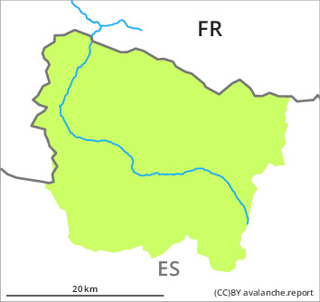
Danger level
2200m
Avalanche Problem

Wind-drifted snow

2200m

Gliding snow
2000m

Fresh wind slabs at intermediate and high altitudes. Moist snow slides and gliding avalanches are possible in isolated cases.
Some snow will fall on Monday. As a consequence of new snow and northwesterly wind, rather small wind slabs will form in the course of the day. The fresh wind slabs will form in particular in gullies and bowls, and behind abrupt changes in the terrain. They are bonding poorly with the old snowpack in particular on wind-protected shady slopes and at intermediate and high altitudes. The fresh wind slabs are mostly shallow but can in some cases be released easily. In addition very occasional small and, in isolated cases, medium-sized gliding avalanches and moist snow slides are possible.
Snowpack
>
Over a wide area 2 to 5 cm of snow, and even more in some localities, will fall until the evening above approximately 2000 m. The sometimes strong wind will transport the new snow significantly. Some fresh snow and very particularly the isolated small winds slabs that are forming are bonding poorly with the old snowpack in many places in particular on wind-protected shady slopes. In particular near-ridge shady slopes: In many places there is a danger of falling on the hard snow surface. All aspects and intermediate and high altitudes: Faceted weak layers exist in the centre of the old snowpack in particular in areas where the snow cover is rather shallow.
Above approximately 2000 m there are 100 to 200 cm of snow, and even more in some localities. Snow depths vary greatly at elevated altitudes, depending on the infuence of the wind.
Above approximately 2000 m there are 100 to 200 cm of snow, and even more in some localities. Snow depths vary greatly at elevated altitudes, depending on the infuence of the wind.
Tendency
Tuesday: Slight increase in danger of moist avalanches as a consequence of warming during the day and solar radiation.