AM
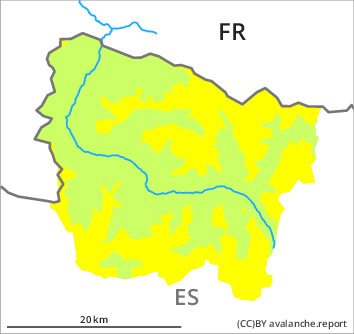
Danger level
2000m
Avalanche Problem

Wind-drifted snow

2000m

PM
Danger level

2000m
Avalanche Problem
Wind-drifted snow
2000m

Wind slabs as the day progresses.
As a consequence of new snow and a gathering strong wind from northwesterly directions, avalanche prone wind slabs will form in the course of the day over a wide area. The fresh wind slabs can in many cases be released by people, but they will be small in most cases. This applies especially on very steep northeast, east and south facing slopes, as well as in shady places that are protected from the wind above approximately 2000 m.
The avalanche prone locations are barely recognisable because of the poor visibility. Backcountry touring calls for experience in the assessment of avalanche danger.
The avalanche prone locations are barely recognisable because of the poor visibility. Backcountry touring calls for experience in the assessment of avalanche danger.
Snowpack
>
Over a wide area 5 to 10 cm of snow, and even more in some localities, will fall until the evening above approximately 1500 m. The northwesterly wind will transport the new snow significantly. The fresh wind slabs will be deposited on weak layers in all aspects.
Above approximately 2000 m there are 100 to 200 cm of snow, and even more in some localities. Snow depths vary greatly at elevated altitudes, depending on the infuence of the wind.
The weather report and anticipated change in the avalanche danger are uncertain. The avalanche danger should be investigated very thoroughly in the relevant locality.
Tendency
Tuesday: In the course of the day the previously small wind slabs will increase in size appreciably.