Danger level
2000m
Avalanche Problem

Wind-drifted snow

2000m

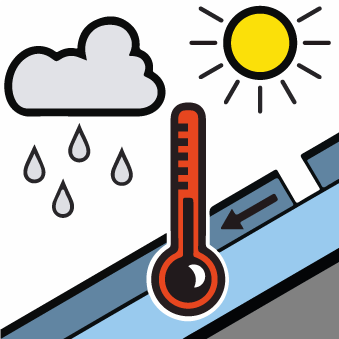
Wet snow


A mostly favourable avalanche situation will prevail. Dry slab avalanches and moist snow slides during the day are possible in isolated cases as before.
The hard wind slabs can still be released in particular on very steep, little used north and east facing slopes above approximately 2000 m. Caution is to be exercised at their margins in particular. They are lying on weak layers in particular on wind-protected shady slopes. In very isolated cases the avalanches in these loacations are medium-sized.
In addition the more recent wind slabs of Saturday adjacent to ridgelines on north and west facing slopes and at high altitudes are capable of being triggered now as before. They are very small but in some cases prone to triggering.
On very steep sunny slopes small moist snow slides are possible as the day progresses in all altitude zones. Very steep grassy slopes: In addition a latent danger of gliding avalanches exists.
Snowpack
>
The old wind slabs are poorly bonded with the old snowpack on wind-protected shady slopes. Shooting cracks when stepping on the snowpack and stability tests indicate the unfavourable bonding of the snowpack in particular on wind-loaded slopes. The fresh wind slabs have settled a little.
On Tuesday it will be very warm. Steep sunny slopes: The surface of the snowpack will already soften in the late morning. Very steep shady slopes and adjacent to ridgelines: There is a danger of falling on the hard crust.
On Tuesday it will be very warm. Steep sunny slopes: The surface of the snowpack will already soften in the late morning. Very steep shady slopes and adjacent to ridgelines: There is a danger of falling on the hard crust.
Tendency
On Wednesday it will be very cloudy. Over a wide area 5 to 10 cm of snow will fall above approximately 1500 m. Significant decrease in danger of gliding avalanches and moist snow slides as the temperature drops. Gradual increase in danger of dry avalanches as a consequence of the new snow.