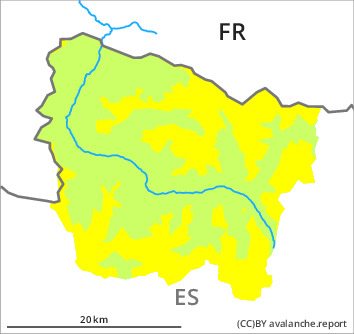
Danger level

2000m
Avalanche Problem
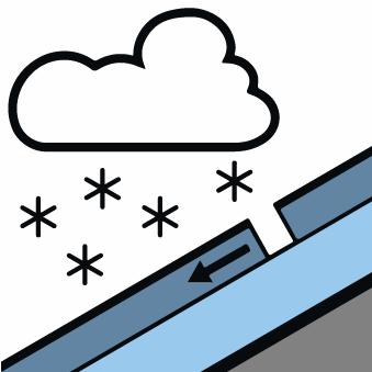
New snow

2000m


Wind-drifted snow
2300m

New snow and wind slabs as the day progresses. Weakly bonded old snow on rather lightly snow-covered shady slopes.
As a consequence of the new snow more frequent dry snow slides and avalanches are to be expected as the day progresses, but they will be mostly small. The avalanche prone locations are to be found in particular on very steep shady slopes above approximately 2000 m. As a consequence of new snow and a light to moderate wind from southeasterly directions, soft wind slabs will form in particular adjacent to ridgelines on west, north and east facing slopes. The fresh wind slabs can be released easily.
The old wind slabs are poorly bonded with the old snowpack in particular on very steep shady slopes and at high altitudes and in high Alpine regions. The avalanche prone locations are to be found especially adjacent to ridgelines and in gullies and bowls. In particular in areas where the snow cover is rather shallow Explanation: "these" may only stand for "these avalanches" can be triggered in the faceted old snow and reach medium size in isolated cases.
Tops and ridges of the divide with Haute Garonne and Pallaresa In addition a latent danger of gliding avalanches exists. Backcountry touring and other off-piste activities call for meticulous route selection.
Snowpack
>
The new snow of the last few days is lying on a crust in all aspects. This snow is loosely bonded in particular on wind-protected shady slopes and above the tree line. Has bonded on steep sunny slopes. Monday: Up to 5 cm of snow, and even more in some localities, will fall above approximately 2000 m. In particular adjacent to ridgelines and in pass areas high altitudes and the high Alpine regions: The southeasterly wind will transport the new snow. The high humditiy will give rise as the day progresses to increasing moistening of the snowpack in all aspects in particular at low and intermediate altitudes.
In particular very steep shady slopes areas where the snow cover is rather shallow: Weak layers in the old snowpack necessitate caution.
Above approximately 2000 m there are 100 to 200 cm of snow. At high altitudes and in high Alpine regions snow depths vary greatly, depending on the infuence of the wind.
Tendency
Tuesday: Hardly any decrease in danger of dry avalanches as a consequence of new snow and wind.