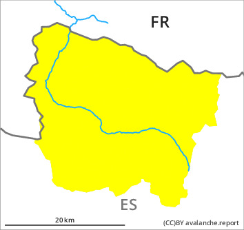
Danger level

2300m
Avalanche Problem

Wind slab

2300m

Gliding snow
1500m

Wind slabs and gliding snow require caution.
The fresh wind slabs must be evaluated with care and prudence in particular on very steep, little used shady slopes and at high altitudes and in high Alpine regions. As a consequence of new snow and a sometimes moderate wind from southeasterly directions, clearly visible wind slabs formed on Saturday. These can in isolated cases be released easily, but they will be small in most cases. The avalanche prone locations are to be found in particular adjacent to ridgelines and in pass areas and at transitions into gullies and bowls.
On extremely steep grassy slopes individual small and, in isolated cases, medium-sized gliding avalanches are possible. In addition as the day progresses on south and west facing slopes, some moist snow slides are to be expected.
On extremely steep grassy slopes individual small and, in isolated cases, medium-sized gliding avalanches are possible. In addition as the day progresses on south and west facing slopes, some moist snow slides are to be expected.
Snowpack
>
The fresh and older wind slabs are lying on soft layers especially on wind-protected shady slopes. They remain in some cases prone to triggering. On Monday it will be sunny. As a consequence of rising temperatures and significant solar radiation the snowpack will settle in the course of the day.
At intermediate altitudes there are 30 to 50 cm of snow, and even more in some localities. At high altitudes and in high Alpine regions snow depths vary greatly, depending on the infuence of the wind.
At intermediate altitudes there are 30 to 50 cm of snow, and even more in some localities. At high altitudes and in high Alpine regions snow depths vary greatly, depending on the infuence of the wind.
Tendency
Tuesday: Slight increase in danger of gliding avalanches and moist snow slides as a consequence of the moist air. Significant decrease in danger of dry avalanches.