AM
Danger level
2000m
Avalanche Problem

Wind slab

2000m


New snow


PM
Danger level

2000m
Avalanche Problem
Wind slab
2000m
New snow
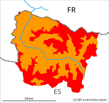
New snow and wind slabs in all altitude zones. Outside marked and open pistes a very critical avalanche situation will prevail.
On wind-loaded slopes the avalanche danger is high (level 4). The large quantity of fresh snow and in particular the often large wind slabs can be released easily or naturally. The avalanches are large and easily released. The avalanche prone locations are to be found on east to south to west facing aspects and in shady places that are protected from the wind in all altitude zones.
As a consequence of the ceasing of precipitation there will be a gradual decrease in the avalanche danger to level 3 (considerable) as the day progresses.
Ski touring, freeriding and snowshoe hiking are to be restricted to flat or controlled terrain.
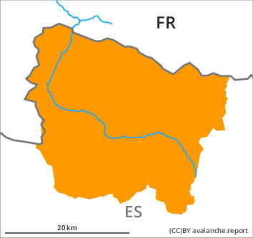
As a consequence of the ceasing of precipitation there will be a gradual decrease in the avalanche danger to level 3 (considerable) as the day progresses.
Ski touring, freeriding and snowshoe hiking are to be restricted to flat or controlled terrain.
Snowpack
>
As a consequence of new snow and a strong to storm force northerly wind, large wind slabs formed during the night in particular on east, south and west facing slopes. The new snow and wind slabs of the last four days are lying on the unfavourable surface of an old snowpack especially on little used shady slopes above approximately 1800 m. Released avalanches and distinct weak layers deep in the old snowpack indicate a dangerous avalanche situation. Since Monday on very steep north, east and south facing slopes numerous small to medium-sized avalanches were reported.
Up to 70 cm of snow has fallen since Sunday above approximately 1800 m.
Above the tree line there are 60 to 90 cm of snow, and even more in some localities. At high altitude snow depths vary greatly, depending on the infuence of the wind.
Up to 70 cm of snow has fallen since Sunday above approximately 1800 m.
Above the tree line there are 60 to 90 cm of snow, and even more in some localities. At high altitude snow depths vary greatly, depending on the infuence of the wind.
Tendency
Saturday: 10 to 20 cm of snow will fall from midday in all altitude zones. The avalanche danger will not decrease for the time being.