AM
Danger level
2000m
Avalanche Problem

Wind slab

2000m

PM
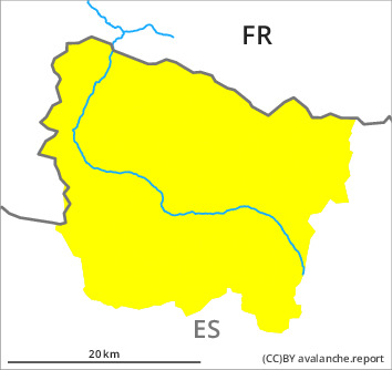
Danger level

Avalanche Problem
Wind slab

Fresh wind slabs represent the main danger. In the course of the day potentially danger level 2 (moderate) will be reached on shady slopes.
The sometimes strong wind will transport the loosely bonded old snow. The fresh wind slabs will form adjacent to ridgelines on north and west facing slopes. They are bonding poorly with the old snowpack in particular on shady slopes. The avalanches are rather small but in many cases easily released.
As a consequence of new snow and strong wind the prevalence and size of the avalanche prone locations will increase in the afternoon.
As a consequence of new snow and strong wind the prevalence and size of the avalanche prone locations will increase in the afternoon.
Snowpack
>
Some snow will fall on Tuesday in particular in the east and in the south. The wind will be moderate to strong adjacent to ridgelines.
Above the tree line there are 50 to 70 cm of snow, and even more in some localities. At intermediate and high altitudes snow depths vary greatly, depending on the infuence of the wind. Wind-protected shady slopes: The snowpack is faceted and weak. Sunny slopes: The snowpack is well consolidated and its surface has a melt-freeze crust.
Above the tree line there are 50 to 70 cm of snow, and even more in some localities. At intermediate and high altitudes snow depths vary greatly, depending on the infuence of the wind. Wind-protected shady slopes: The snowpack is faceted and weak. Sunny slopes: The snowpack is well consolidated and its surface has a melt-freeze crust.
Tendency
On Wednesday it will be mostly sunny. The more recent wind slabs are bonding only slowly with the old snowpack.