Danger level
2000m
Avalanche Problem

Persistent weak layer

2000m


Wet snow
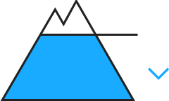
2500m

Dry slab avalanches are possible in isolated cases as before. Moist snow slides are possible from the afternoon.
The hard wind slabs can still be released in some cases on very steep, little used north facing slopes above approximately 2000 m, especially at their margins. They are lying on top of a weakly bonded old snowpack especially on wind-protected shady slopes. In very isolated cases the avalanches are medium-sized. In particular at the southern border of Aran the avalanche prone locations are more prevalent and the danger is slightly greater. Northern half of Aran Distinct weak layers in the old snowpack can be released in isolated cases in particular on very steep shady slopes. These are rather small.
As the moisture increases moist snow slides are possible from midday, but they will be mostly small.
As the moisture increases moist snow slides are possible from midday, but they will be mostly small.
Snowpack
>
The hard wind slabs are lying on top of a weakly bonded old snowpack on shady slopes. Snow profiles and stability tests indicate the existence of a weak snowack on wind-protected shady slopes.
The rain will give rise in the afternoon to slight moistening of the snowpack on shady slopes at low and intermediate altitudes. In all regions less snow than usual is lying. At low altitude from a snow sport perspective, insufficient snow is lying. At intermediate and high altitudes there are 40 to 60 cm of snow, and even more in some localities. In high Alpine regions snow depths vary greatly, depending on the infuence of the wind.
The rain will give rise in the afternoon to slight moistening of the snowpack on shady slopes at low and intermediate altitudes. In all regions less snow than usual is lying. At low altitude from a snow sport perspective, insufficient snow is lying. At intermediate and high altitudes there are 40 to 60 cm of snow, and even more in some localities. In high Alpine regions snow depths vary greatly, depending on the infuence of the wind.
Tendency
Wednesday: Gradual increase in danger of dry avalanches as a consequence of the snowfall. Gradual decrease in danger of moist avalanches as the temperature drops.