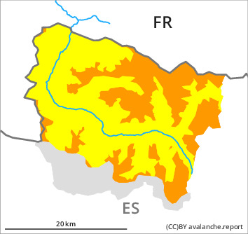
Danger level

2000m
Avalanche Problem

Wind slab

2000m


New snow
1800m

Restraint is advisable on this first sunny day.
Fresh snow and large quantities of wind-drifted snow represent the main danger.
The fresh snow as well as the wind slabs that are being formed by the southerly wind must be evaluated with care and prudence in particular on steep shady slopes and at intermediate and high altitudes. Dry avalanches can over a wide area be released very easily or triggered naturally. In particular on wind-protected shady slopes they can be triggered in the faceted old snow and reach medium size. In these regions the avalanche prone locations are more prevalent and the danger is greater.
Snowpack
>
20 to 30 cm of snow, and up to 40 cm in some localities, will fall until Friday above approximately 2000 m. The wind will be strong to storm force in some localities. The wind will transport the new snow significantly. The new snow and wind slabs will be deposited on the unfavourable surface of an old snowpack in particular on wind-protected shady slopes and at intermediate and high altitudes. They will become increasingly prone to triggering. On Friday it will be sunny.
In high Alpine regions snow depths vary greatly, depending on the infuence of the wind. At intermediate and high altitudes there are 50 to 120 cm of snow, and even more in some localities.
In high Alpine regions snow depths vary greatly, depending on the infuence of the wind. At intermediate and high altitudes there are 50 to 120 cm of snow, and even more in some localities.
Tendency
Saturday: Temporary decrease in danger of dry avalanches as the snowfall eases.