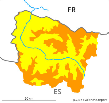
Danger level

2100m
Avalanche Problem

Wind slab

2100m

Wind slab
2100m

Fresh and somewhat older wind slabs represent the main danger.
The fresh and somewhat older wind slabs must be evaluated with care and prudence in all aspects and above the tree line. The fresh wind slabs will form in particular adjacent to ridgelines on east and south facing slopes and generally at high altitudes. They can be released very easily, but they will be small in most cases. The somewhat older wind slabs are sometimes deep but can in some cases be released easily especially at their margins. In particular on wind-protected shady slopes they can be triggered in the faceted old snow and reach a dangerous size. The avalanche prone locations are sometimes covered with new snow and are barely recognisable because of the poor visibility. The current avalanche situation calls for defensive route selection.
Snowpack
>
20 to 40 cm of snow, and even more in some localities, has fallen since Wednesday above approximately 2000 m. The southerly wind has transported the new snow significantly. Fresh snow and large quantities of wind-drifted snow are lying on the unfavourable surface of an old snowpack in particular on wind-protected shady slopes. They remain in some cases prone to triggering in particular on very steep, little used shady slopes. On Sunday it will be cold. Up to 5 cm of snow, and even more in some localities, has fallen since yesterday. The wind will be strong to storm force in the vicinity of peaks in particular in the southernmost and easternmost part of Aran. The northerly wind will transport the new snow significantly.
In high Alpine regions snow depths vary greatly, depending on the infuence of the wind. At intermediate and high altitudes there are 50 to 120 cm of snow, and even more in some localities.
In high Alpine regions snow depths vary greatly, depending on the infuence of the wind. At intermediate and high altitudes there are 50 to 120 cm of snow, and even more in some localities.
Tendency
Monday: Further increase in danger of dry avalanches as a consequence of new snow and wind.