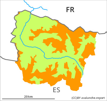
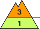
Danger level
1800m
Avalanche Problem

Persistent weak layer

1800m


Wind slab
2000m

Wind slabs and weakly bonded old snow are to be critically assessed.
The fresh wind slabs have formed in particular adjacent to ridgelines on northeast, east and south facing slopes and generally at high altitudes. As a consequence of new snow and a sometimes strong northerly wind, further wind slabs will form by the early morning. They can be released very easily and reach medium size. The somewhat older wind slabs are sometimes deep but can in some cases be released easily especially at their margins. In particular on wind-protected shady slopes they can be triggered in the faceted old snow and reach a dangerous size. The avalanche prone locations are covered with new snow and are barely recognisable because of the poor visibility. The current avalanche situation calls for experience in the assessment of avalanche danger and restraint.
Snowpack
>
20 to 40 cm of snow, and even more in some localities, has fallen since Wednesday above approximately 2000 m. The strong wind has transported the new snow significantly. Fresh snow and large quantities of wind-drifted snow of the last few days are lying on the unfavourable surface of an old snowpack in particular on wind-protected shady slopes. They remain very prone to triggering in particular on very steep, little used shady slopes. Released avalanches and whumpfing sounds and the formation of shooting cracks when stepping on the snowpack confirm a very precarious avalanche situation on shady slopes. On Monday it will be cold. 5 to 10 cm of snow, and even more in some localities, will fall until the early morning. The wind will be strong to storm force in the vicinity of peaks in particular in the southernmost and easternmost part of Aran. The northerly wind will transport the new snow significantly. The fresh wind slabs will become increasingly prone to triggering.
In high Alpine regions snow depths vary greatly, depending on the infuence of the wind. At intermediate and high altitudes there are 50 to 120 cm of snow, and even more in some localities.
In high Alpine regions snow depths vary greatly, depending on the infuence of the wind. At intermediate and high altitudes there are 50 to 120 cm of snow, and even more in some localities.
Tendency
Tuesday: Slight decrease in danger of dry avalanches as the snowfall eases.