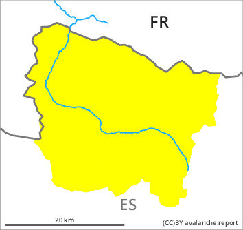
Danger level

1800m
Avalanche Problem

Persistent weak layer

1800m


Wet snow
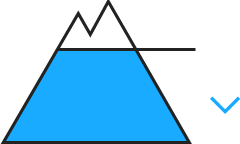
2300m

Weakly bonded old snow on shady slopes. Moist snow slides and gliding avalanches are to be expected during the day.
The old wind slabs of last week are lying on weak layers on northwest to north to east facing aspects and generally at intermediate and high altitudes. Sometimes the avalanches in these loacations are medium-sized. These can as before be released by people. Transitions from a shallow to a deep snowpack where weaknesses exist in the old snowpack are especially precarious.
Very steep sunny slopes: Below approximately 2300 m small gliding avalanches and moist snow slides are possible.
In shady places that are protected from the wind: The covering of new snow is faceted and weak. This snow can be released very easily. These are only shallow.
Very steep sunny slopes: Below approximately 2300 m small gliding avalanches and moist snow slides are possible.
In shady places that are protected from the wind: The covering of new snow is faceted and weak. This snow can be released very easily. These are only shallow.
Snowpack
>
Shady slopes: In its middle, the snowpack consists of faceted crystals; its surface consists of loosely bonded snow.
Sunny slopes: Outgoing longwave radiation during the night will be quite good. Sunshine and high temperatures will give rise from early morning to increasing moistening of the snowpack on steep slopes.
At intermediate and high altitudes there are 60 to 120 cm of snow, and even more in some localities. On steep sunny slopes at low and intermediate altitudes hardly any snow is lying.
Tendency
Monday: The danger of dry and moist avalanches will persist.