Danger level

2400m
Avalanche Problem

Wet snow
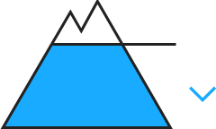
2400m


Wind slab

2200m

The backcountry and freeriding conditions are dangerous.
Wet snow represents the main danger.
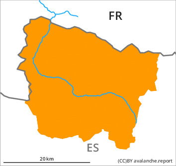
Below approximately 2400 m medium-sized and, in isolated cases, large wet avalanches are possible as the day progresses. These can be released very easily. The avalanche prone locations are to be found in particular on steep northwest to east to southeast facing slopes. As a consequence of the precipitation the avalanche prone locations will become more prevalent as the day progresses.
The fresh wind slabs remain for the foreseeable future prone to triggering on northwest to north to southeast facing aspects above approximately 2200 m. Explanation: "these" may only stand for "these avalanches" are small but can be released easily in some cases by a single winter sport participant. The avalanche prone locations are to be found in particular in steep terrain at high altitude and in gullies and bowls, and behind abrupt changes in the terrain. Extensive experience in the assessment of avalanche danger is required.
The fresh wind slabs remain for the foreseeable future prone to triggering on northwest to north to southeast facing aspects above approximately 2200 m. Explanation: "these" may only stand for "these avalanches" are small but can be released easily in some cases by a single winter sport participant. The avalanche prone locations are to be found in particular in steep terrain at high altitude and in gullies and bowls, and behind abrupt changes in the terrain. Extensive experience in the assessment of avalanche danger is required.
Snowpack
>
Up to 2400 m rain will fall until Sunday over a wide area. The surface of the snowpack is hardly frozen at all and will soften quickly. The wind will be strong to storm force adjacent to ridgelines. The northwesterly wind will transport only a little snow.
Shady slopes and above approximately 2000 m: In its middle, the snowpack is unfavourably layered.
At intermediate and high altitudes there are 60 to 120 cm of snow, and even more in some localities. On steep sunny slopes at low and intermediate altitudes hardly any snow is lying.
Shady slopes and above approximately 2000 m: In its middle, the snowpack is unfavourably layered.
At intermediate and high altitudes there are 60 to 120 cm of snow, and even more in some localities. On steep sunny slopes at low and intermediate altitudes hardly any snow is lying.
Tendency
Sunday: Gradual decrease in danger of moist avalanches as a consequence of the ceasing of precipitation.