Danger level
Avalanche Problem

Wet snow


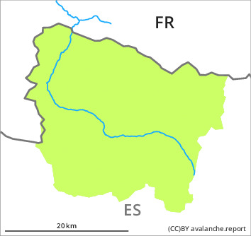
The Avalanche Warning Service currently has only a small amount of information that has been collected in the high Alpine regions, so that the avalanche danger should be investigated especially thoroughly in the relevant locality.
Moist snow slides are the main danger.
On very steep sunny slopes moist snow slides are possible as the day progresses, but they will be mostly small. They can be released by people or triggered naturally.
In addition the hard wind slabs at elevated altitudes are capable of being triggered in very isolated cases. They are lying on a crust. The avalanches in these loacations are only small and can mostly only be released by large loads.
Early morning: There is a danger of falling on the hard crust.
In addition the hard wind slabs at elevated altitudes are capable of being triggered in very isolated cases. They are lying on a crust. The avalanches in these loacations are only small and can mostly only be released by large loads.
Early morning: There is a danger of falling on the hard crust.
Snowpack
>
The clearly visible wind slabs of Monday have bonded well with the old snowpack. On Thursday it will be warm. The surface of the snowpack will freeze to form a strong crust and will already soften in the late morning. The wind will be moderate to strong in the vicinity of peaks. The southerly foehn wind will transport only a little snow.
In all regions less snow than usual is lying.
On shady slopes at low altitude no snow is lying. At intermediate and high altitudes there are 20 to 40 cm of snow, and even more in some localities. On steep sunny slopes in all altitude zones only a little snow is lying.
In all regions less snow than usual is lying.
On shady slopes at low altitude no snow is lying. At intermediate and high altitudes there are 20 to 40 cm of snow, and even more in some localities. On steep sunny slopes in all altitude zones only a little snow is lying.
Tendency
Friday: The danger of moist avalanches will decrease gradually.