Danger level
treeline
Avalanche Problem

Wet snow

Treeline


Wind slab


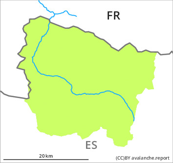
The Avalanche Warning Service currently has only a small amount of information that has been collected in the high Alpine regions, so that the avalanche danger should be investigated especially thoroughly in the relevant locality.
Moist snow slides are possible in isolated cases as before. Fresh wind slabs towards the evening.
As the moisture increases more moist snow slides are possible as the day progresses, but they will be mostly small. They can be released by people or triggered naturally.
As a consequence of new snow and a moderate westerly wind, mostly shallow wind slabs will form towards the evening in particular adjacent to ridgelines as well as at elevated altitudes. They will be deposited on a crust. The avalanches in these loacations are only small but can be released easily in some cases even by a single winter sport participant.
Early morning: There is a danger of falling on the hard crust.
Snowpack
>
The clearly visible wind slabs of Monday have bonded well with the old snowpack. On Friday it will be sunny at times. The surface of the snowpack will freeze to form a strong crust and will soften during the day. Some snow will fall in the evening. The westerly wind will transport the new snow.
In all regions less snow than usual is lying. At intermediate and high altitudes there are 10 to 40 cm of snow, and even more in some localities.
In all regions less snow than usual is lying. At intermediate and high altitudes there are 10 to 40 cm of snow, and even more in some localities.
Tendency
Saturday: The danger of moist avalanches will decrease quickly. Gradual increase in danger of dry avalanches as a consequence of new snow and wind.