AM
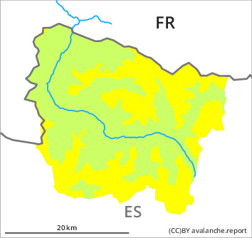
Danger level

2100m
Avalanche Problem

Wind slab

2100m


New snow


PM
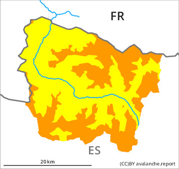
Danger level

2100m
Avalanche Problem
Wind slab
2100m
New snow
New snow and wind slabs require caution. In the course of the day probably danger level 3 (considerable) will be reached above approximately 2100 m.
As a consequence of new snow and a moderate to strong wind from northwesterly directions, wind slabs formed during the course of the night on northeast, east and south facing slopes. They are lying on a crust in particular on shady slopes. As a consequence of low temperatures, snowfall above approximately 1500 m and the occasionally strong northerly wind, the snow drift accumulations will increase in size in the course of the day. The fresh snow and the wind slabs can be released easily, or, in isolated cases naturally and generally at intermediate and high altitudes. The avalanches are medium-sized and in many cases easily released.
The avalanche prone locations are numerous and are barely recognisable because of the poor visibility. The conditions are treacherous for ski touring, freeriding and snowshoe hiking in steep terrain.
The avalanche prone locations are numerous and are barely recognisable because of the poor visibility. The conditions are treacherous for ski touring, freeriding and snowshoe hiking in steep terrain.
Snowpack
>
15 cm of snow, and even more in some localities, has fallen since yesterday. 10 to 20 cm of snow will fall until the evening above approximately 1500 m. The strong wind will transport the new snow significantly.
On shady slopes at high altitude there are 20 to 50 cm of snow, and even more in some localities.
On shady slopes at high altitude there are 20 to 50 cm of snow, and even more in some localities.
Tendency
Monday: Gradual decrease in danger of dry avalanches as the snowfall eases. Rapid increase in danger of moist avalanches as a consequence of solar radiation.