Danger level
Avalanche Problem

Wet snow


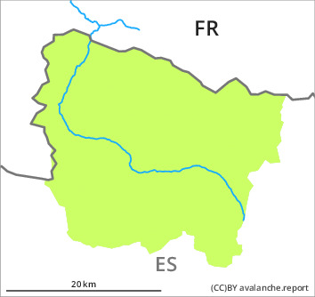
This is the final hazard map for the winter 2022/23. Regular avalanche bulletins with hazard maps will appear again from around the start of December, depending on the snow situation.
Moist snow slides during the day and gliding avalanches are possible in isolated cases as before.
As the moisture increases more moist and wet snow slides are possible as the day progresses, but they will be mostly small. These can be released by people or triggered naturally. Extremely steep grassy slopes: Gliding avalanches can also occur.
In addition the old wind slabs on north facing slopes and at elevated altitudes are capable of being triggered in very isolated cases still.
The conditions are generally favourable for backcountry touring. Apart from the danger of being buried, restraint should be exercised in particular in view of the danger of avalanches sweeping people along and giving rise to falls. Early morning: In steep terrain there is a danger of falling on the hard crust.
Snowpack
>
The snowpack will be in most cases stable. The fresh snow of last week and in particular the wind slabs have bonded well with the old snowpack in all aspects. The spring-like weather conditions on Monday will give rise to increasing moistening of the snowpack in all aspects.
On shady slopes at intermediate and high altitudes there are 10 to 50 cm of snow, and even more in some localities. At elevated altitudes snow depths vary greatly, depending on the infuence of the wind. At low altitude from a snow sport perspective, in most cases insufficient snow is lying.
On shady slopes at intermediate and high altitudes there are 10 to 50 cm of snow, and even more in some localities. At elevated altitudes snow depths vary greatly, depending on the infuence of the wind. At low altitude from a snow sport perspective, in most cases insufficient snow is lying.
Tendency
Tuesday: The danger of moist and wet avalanches will already increase in the early morning.