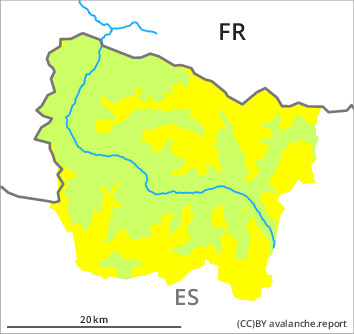
Danger level

2000m
Avalanche Problem

Wind slab

2000m


New snow
2000m

New snow and wind slabs in all aspects.
The cold fresh snow and the mostly small wind slabs formed by the sometimes strong wind can be released easily in all aspects. The avalanche prone locations for dry avalanches are to be found in particular on wind-loaded slopes and on wind-protected shady slopes. Fresh and somewhat older wind slabs have formed adjacent to ridgelines on north, east and south facing slopes and generally at high altitudes. These are covered with new snow in some cases and therefore difficult to recognise. The dry avalanches are rather small. As a consequence of solar radiation loose snow slides are possible as the day progresses, but they will be mostly small. Even a small avalanche can sweep people along and give rise to falls.
The Avalanche Warning Service currently has only a small amount of information about the snowpack, so that the avalanche danger should be investigated especially thoroughly in the relevant locality.
The Avalanche Warning Service currently has only a small amount of information about the snowpack, so that the avalanche danger should be investigated especially thoroughly in the relevant locality.
Snowpack
>
Up to high altitudes rain fell on Friday. The rain gave rise to extreme moistening of the snowpack in all aspects in all altitude zones. As a consequence of sharply falling temperatures the snowpack will consolidate at the weekend. 10 to 15 cm of snow, and even more in some localities, fell in the past few hours above approximately 1500 m. The sometimes strong wind has transported the new snow. Fresh and somewhat older wind slabs remain in some cases prone to triggering.
Above approximately 2000 m there are 20 to 30 cm of snow, and even more in some localities. Snow depths vary greatly at intermediate and high altitudes, depending on the infuence of the wind. At low altitude from a snow sport perspective, insufficient snow is lying.
Above approximately 2000 m there are 20 to 30 cm of snow, and even more in some localities. Snow depths vary greatly at intermediate and high altitudes, depending on the infuence of the wind. At low altitude from a snow sport perspective, insufficient snow is lying.
Tendency
Monday: Further increase in danger of dry avalanches as a consequence of new snow and wind.