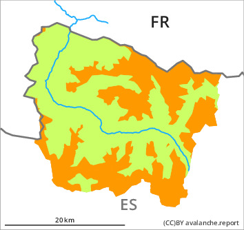
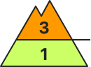
Danger level
2000m
Avalanche Problem

New snow

2000m


Wet snow


More snow than expected has fallen. New snow represents the main danger.
As a consequence of the snowfall dry avalanches are to be expected as the day progresses, even medium-sized ones. These can be released by small loads or triggered naturally. The avalanche prone locations are to be found in particular on steep slopes above approximately 2000 m and adjacent to ridgelines and in gullies and bowls.
As a consequence of warming during the day and solar radiation more frequent small and, in isolated cases, medium-sized moist avalanches are to be expected in all altitude zones.
Backcountry touring and other off-piste activities call for experience in the assessment of avalanche danger and caution.
Snowpack
>
Over a wide area 20 to 30 cm of snow, and even more in some localities, fell in the past few hours above approximately 1800 m. In the evening the wind was stronger than expected briefly.
Sunshine and high temperatures will give rise as the day progresses to increasing moistening of the snowpack on steep sunny slopes in all altitude zones.
Above approximately 2000 m there are 40 to 60 cm of snow, and even more in some localities. At low altitude from a snow sport perspective, insufficient snow is lying.
Tendency
Sunday: The activity of dry avalanches will gradually increase. In some localities increase in danger of moist avalanches as a consequence of warming during the day and solar radiation.