Danger level

Avalanche Problem
Gliding snow


Wet snow
Moist and wet avalanches and gliding avalanches are likely to occur already in the early morning.
As the penetration by moisture increases more wet and gliding avalanches are possible at any time. In particular on northwest, northeast and east facing slopes they can be triggered in deep layers of the snowpack and reach large size in isolated cases. The avalanche prone locations are to be found on sunny slopes in all altitude zones and on shady slopes below approximately 2500 m. As the day progresses in all aspects there will be a gradual increase in the avalanche danger.
Backcountry tours should be started and concluded early.
Backcountry tours should be started and concluded early.
Snowpack
>
Outgoing longwave radiation during the night will be severely restricted. The surface of the snowpack will freeze very little and will soften quickly. Moisture can reach the persistent weak layers buried within the snowpack and reactivate them.
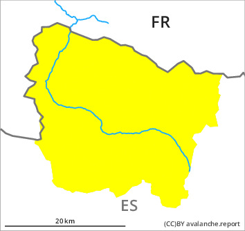
Above approximately 2000 m there are 60 to 100 cm of snow, and even more in some localities. At high altitude snow depths vary greatly, depending on the infuence of the wind.
Above approximately 2000 m there are 60 to 100 cm of snow, and even more in some localities. At high altitude snow depths vary greatly, depending on the infuence of the wind.
Tendency
Saturday: The surface of the snowpack will cool hardly at all during the overcast night and will soften quickly. The danger of wet and gliding avalanches will already increase in the early morning.