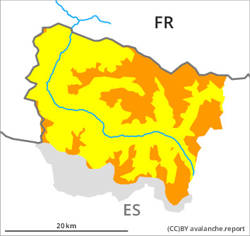
Danger level

2400m
Avalanche Problem

Wind slab

2400m


Wet snow
2400m

Wind slabs at high altitude. Moist and wet avalanches as the day progresses.
Less new snow than expected in the south and in the west: The wind slabs can be released easily. or in isolated cases naturally, in particular on shady slopes at high altitudes and in high Alpine regions. In isolated cases the avalanches are medium-sized. The avalanche prone locations are to be found especially adjacent to ridgelines above approximately 2400 m and in gullies and bowls, and behind abrupt changes in the terrain. The prevalence of such avalanche prone locations will increase as the day progresses.
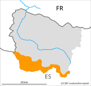
As a consequence of the rain, the likelihood of moist avalanches being released will increase a little in all aspects at low and intermediate altitudes. Sometimes the avalanches in these regions are medium-sized.
Backcountry touring and other off-piste activities call for great caution and restraint.
Snowpack
>
20 to 40 cm of snow, and even more in some localities, fell in the last four days. In some localities 10 to 20 cm of snow will fall until the evening above approximately 2200 m. The southerly wind will transport the new snow significantly.
The rain will give rise as the day progresses to rapid moistening of the snowpack in all aspects below approximately 2200 m. The new snow and wind slabs have bonded well with the old snowpack in all aspects.
The rain will give rise as the day progresses to rapid moistening of the snowpack in all aspects below approximately 2200 m. The new snow and wind slabs have bonded well with the old snowpack in all aspects.
Tendency
Saturday: Gradual increase in danger of dry avalanches as a consequence of the snowfall. Gradual decrease in danger of moist avalanches.