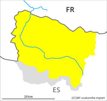
Danger level

2200m
Avalanche Problem

Wind slab

2200m


Wet snow
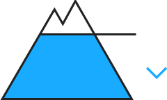
2300m

The weather report and anticipated change in the avalanche danger are uncertain. We recommend that you consult the most recent avalanche bulletin.
Wind slabs and wet snow require caution.
As a consequence of new snow and a moderate to strong southerly wind, wind slabs will form in particular adjacent to ridgelines and in gullies and bowls as well as at intermediate and high altitudes. In some cases the avalanches are medium-sized and very easily released. Shooting cracks when stepping on the snowpack indicate this situation.
As a consequence of the rain moist snow slides and avalanches are to be expected as the day progresses, even medium-sized ones. The avalanche prone locations are to be found on shady slopes at low and intermediate altitudes.
Backcountry touring and other off-piste activities call for extensive experience in the assessment of avalanche danger. The more recent wind slabs are to be avoided whenever possible.
Snowpack
>
The weather will be very cloudy. Over a wide area 15 to 20 cm of snow will fall above approximately 2000 m. The sometimes storm force wind will transport the fresh and old snow significantly. In some cases the wind slabs have bonded poorly with each other and the old snowpack.
Low and intermediate altitudes: The surface of the snowpack will soften quickly.
Low and intermediate altitudes: The surface of the snowpack will soften quickly.
Tendency
Sunday: 40 to 60 cm of snow will fall until the early morning. Significant increase in danger of dry avalanches as a consequence of new snow and strong wind.