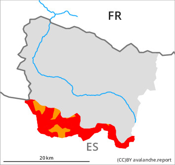
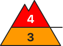
Danger level
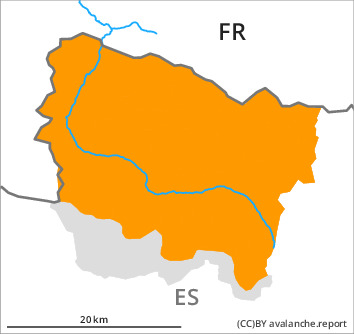
treeline
Avalanche Problem

Wind slab

Treeline


New snow
1800m
It is inadvisable to engage in backcountry touring and snowshoe hiking.
With the end of the intense snowfall, the natural activity of slab avalanches will gradually increase. For this reason the avalanche danger will decrease during the day to level 3 (considerable).
As a consequence of new snow and a moderate to strong wind, wind slabs formed in particular adjacent to ridgelines and in gullies and bowls as well as at intermediate and high altitudes. Over a wide area they will increase in size substantially during the course of the night. Sometimes the avalanches are large and very easily released.
As a consequence of the snowfall snow slides and avalanches are to be expected as the day progresses, in particular medium-sized ones. The avalanche prone locations are to be found on steep sunny slopes and on wind-protected shady slopes.
The peak of avalanche activity will be reached during the second half of the night probably.
Snowpack
>
Evening and night: Over a wide area 50 to 60 cm of snow will fall above approximately 2000 m. The sometimes storm force wind will transport the new snow significantly. During the day: The weather will be partly cloudy.
In some cases the wind slabs have bonded poorly with each other and the old snowpack.
In some cases the wind slabs have bonded poorly with each other and the old snowpack.
Tendency
Monday: Decrease in danger of dry avalanches as a consequence of the ceasing of precipitation.