EARLIER
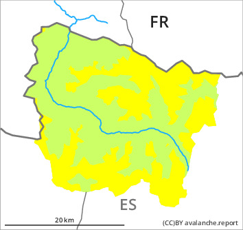
Danger level

2400m
Avalanche Problem

Persistent weak layer

2400m


Wet snow


LATER
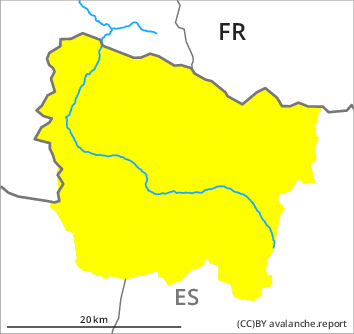
Danger level

2400m
Avalanche Problem
Persistent weak layer
2400m
Wet snow

The avalanche conditions at elevated altitudes are treacherous.
Weakly bonded old snow requires caution. Moist snow slides and avalanches as the day progresses.
In particular high altitudes: Weak layers in the upper part of the snowpack can still be released in some places especially on steep, little used shady slopes. Caution is to be exercised in gullies and bowls, and behind abrupt changes in the terrain. Sometimes they are medium-sized and in some cases easily released. Explanation: "these" may only stand for "these avalanches" can also in isolated cases reach dangerously large size.
Very steep sunny slopes as well as below approximately 2200 m: As the moisture increases more moist avalanches are to be expected as the day progresses, even medium-sized ones. Moist avalanches can occur easily or triggered naturally. Gliding avalanches can also occur.
The current avalanche situation calls for experience in the assessment of avalanche danger and restraint.
Snowpack
>
In particular high altitudes in shady places that are protected from the wind: Large-grained weak layers exist in the top section of the snowpack. They are prone to triggering. Snow profiles and stability tests indicate the unfavourable bonding of the snowpack in these regions.
On Sunday it will be sunny at times. Sunny slopes: The surface of the snowpack will freeze to form a strong crust and will soften earlier than the day before. The light wind will transport only a little snow. The high humditiy will give rise as the day progresses to increasing moistening of the snowpack in all aspects in particular at low and intermediate altitudes.
At intermediate altitudes there are 150 to 200 cm of snow, and even more in some localities. Snow depths vary greatly at high altitudes and in high Alpine regions, depending on the infuence of the wind.
Tendency
Some snow will fall until Monday. The northerly wind will transport the new snow. As a consequence of new snow and a moderate northerly wind, mostly small wind slabs will form during the course of the night. From early morning the weather will be mostly sunny. The danger of dry avalanches will already be elevated in the early morning. The danger of moist avalanches will increase during the day.